
Client: Department of Transportation
BACKGROUND: The Newington branch of the Department of Transportation contacted Central Connecticut State University to see if their internal creative agency, Central Design, would be able to design a series of maps for their new bus line, the CTfastrak.
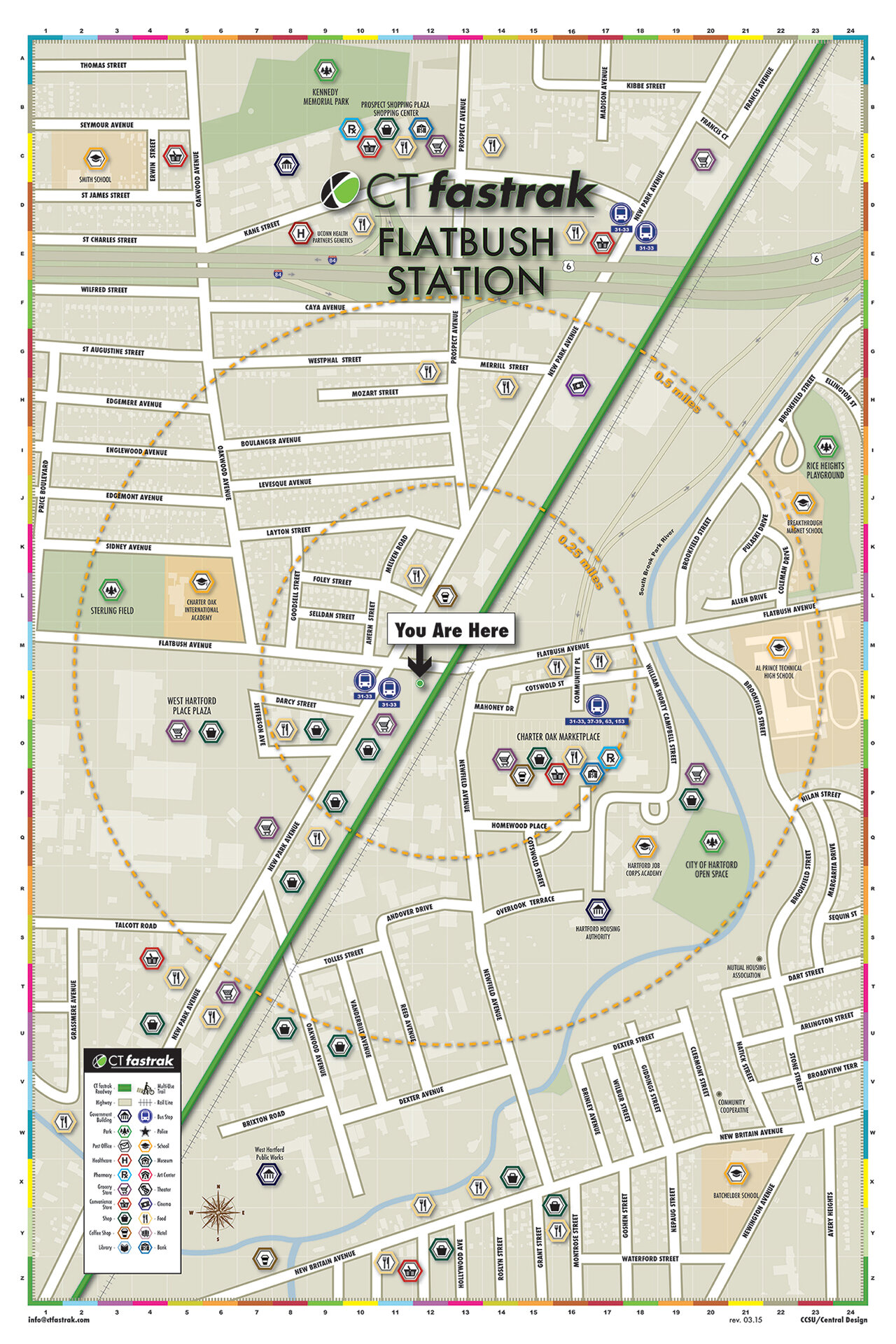
OBJECTIVES
Create a series of maps
Each map to have a clear point for the location’s stop
Each map to show a perimeter of 2 miles from the stop
Local businesses to be featured on maps
Iconography and color palette to reflect businesses
The logo, bus location, and Legend should be prominent on maps
MY ROLE ON PROJECT
For this project, I served as the student team lead, sitting in on meetings with the marketing department from the DOT with the Design department chair from CCSU. In my role as team lead, I oversaw the design and production of each of the maps, delegating different design areas to the students who participated in this project. The overall design team can be seen in the header image of this page.
CCSU Courier Spring 2015 Cover
Cover of the Hartford Courant
Excerpt from the Spring 2015 edition of the CCSU Courier
When CCSU Central Design students first heard about plans for the CTfastrak, they had no idea they would end up creating a high-profile component of the region’s new $347 million rapid transit system.
To help improve mobility and manage congestion in the I-84 New Britain to Hartford corridor, CTfastrak was launched in March as Connecticut’s bus rapid transit (BRT) solution, offering the speed of a rail system with the flexibility of bus service, providing passengers convenient point-to-point service to their destination via a dedicated, bus-only guideway.
In the spring of 2014, officials from the state Department of Transportation (DOT) reached out to Central Design (The Department of Design’s in-house studio) asking if students could create a series of large-scale, colorful, wayfinding maps–one for each of the dedicated transit line’s 10 stations.
Starting with little more than a technical map of each area and some general instructions from DOT, the class, under the guidance of Assistant Professors of Design Eleanor Thornton and Tina Rice, dedicated thousands of volunteer hours creating and revising the wall-mounted maps depicting the new busway line, nearby buildings, and stop-specific businesses and local attractions.

A sample of CTfastrak’s Parkville Station map created by the CCSU Central Design Team
“I’m extremely happy with these maps. There are a lot of hours involved, and the aesthetic flair the students provided is not something we at the DOT would have been able to accomplish. The overall project, I thought, worked out great.”
CTfastrak Maps


Elmwood Map
Example of how the map appears at each station